Autonomous 3D Laser Scanners Are The Future: Immerse Yourself
The challenges of autonomous driving have been making headlines for the past few years, but one area where autonomous technology is making major inroads is in autonomous scanning and surveying technology. Especially with the advent of robust drones for surveying and aerial 3D scanning, autonomous features are helping revolutionize the surveying field in a variety of exciting ways.
If you’ve been surveying with traditional 3D scanners or total stations, then the futuristic possibilities offered by autonomous 3D laser scanners can be particularly exciting. Learn more about how autonomous drones for surveying are making waves in a variety of scanning applications.
What Industries Can Benefit From Autonomous 3D Scanning?
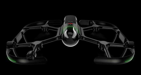
Perhaps one of the flagship autonomous 3D laser scanners is Leica’s BLK2FLY. The BLK2FLY is one of the world’s first autonomous drones for surveying, and it combines its flight capabilities with powerful features like obstacle avoidance in order to quickly, efficiently and safely create 3D data point clouds and scans from the air.
Industries in the architecture, engineering and construction field can greatly benefit from autonomous aerial 3D scans like the ones generated by the BLK2FLY. That’s because when you can use drones for surveying, you’re able to more easily reach hard-to-access points, and create digital twins of building exteriors. These features translate to more accurate scans and less human investment for a more productive surveying job.
From underground surveying to industrial plants and utilities, having access to a surveying device that can handle large environments on its own offers industries of all types a better way to allocate their resources. An employee can set up an autonomous 3D scanner and then focus their attention on other pressing tasks that aren’t able to be automated, thus increasing productivity and efficiency without sacrificing quality.
What’s The Difference Between Autonomous 3D Laser Scanners And Their Predecessors?
Put simply, autonomous 3D laser scanners require much less human intervention in order to work properly and produce accurate results. For example, the Leica BLK ARC offers first-of-its-kind environmental reality capture for robots.
Watch a video of the Leica BLK ARC in action to see how a four-legged robot from Boston Dynamics works with the 3D laser scanner to capture whole environments without the need for human operation at all. The BLK ARC can maneuver through entire floors of a building to create accurate digital twins and 3D point clouds using dual axis LiDAR SLAM that helps to improve control and navigation. The BLK ARC represents the future of 3D laser scanning.
Why Is Autonomous Scanning Exciting?
If you watched the previous video about the Leica BLK ARC and didn’t get excited, perhaps you need to watch it again! Autonomous scanning is exciting for a variety of reasons—namely, how it revolutionizes ease of scanning and safety when completing complex 3D scans on job sites.
Consider how the BLK2FLY literally takes aerial scanning to new heights, allowing for complex facades and out-of-reach areas to be captured. Or think about the BLK ARC surveying a job site that isn’t stable or safe for humans to travel into. Just as robotic vacuums do a better job cleaning than humans do (no matter how erratic their path may look), robotic and autonomous 3D laser scanning is allowing for more dynamic scans than we’ve ever seen before.
Interested in joining the autonomous scanning revolution? Datum Tech Solutions has popular Leica equipment like the BLK2FLY and BLK2GO available for rent or purchase. These 3D laser scanners use powerful autonomous features to streamline your process, improve accuracy and ultimately save you time and money on the job site.
Reach out to Datum Tech Solutions today to learn more about buying or renting their autonomous drones for surveying. Datum Tech can even help you get trained in how to use these exciting, futuristic features.