


SGD-SZ-DRIVE SFERAZERO – Vehicle-Mounted Mobile Mapping System for FARO Laser Scanners
- Price
- $10,950 USD
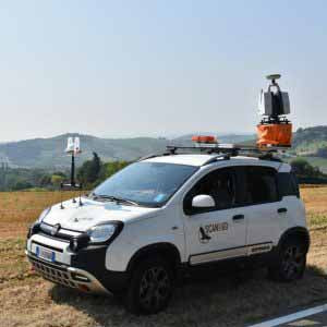
The SGD-SZ-DRIVE SFERAZERO for FARO Laser Scanner is a professional, vehicle-mounted mobile mapping solution designed to transform your FARO scanner into a high-efficiency, road-ready data acquisition system. Built for surveyors, geospatial engineers, and infrastructure teams, this system enables rapid corridor mapping, large-area scanning, and mobile LiDAR capture with unmatched stability and repeatability.
Engineered for seamless FARO scanner integration, the SFERAZERO DRIVE platform elevates and stabilizes the scanner above the vehicle, delivering cleaner scan geometry, expanded field of view, and reduced occlusion in real-world environments. From roadways and rural corridors to construction zones and urban infrastructure, this system dramatically increases coverage speed while maintaining professional-grade data quality.
Designed as a ready-to-deploy mobile solution, the SGD-SZ-DRIVE eliminates the need for custom vehicle builds, temporary mounts, or improvised scanning rigs. The result is faster mobilization, safer operation, and consistent, repeatable results—making it the ideal solution for firms scaling mobile scanning operations with FARO technology.
Features
- Level Plane 16 Radio, Automatic leveler (not dynamic)
- Magnetic Level Bracket
- Orientation target SferaZERO (GNSS receivers & 3D Laser Scanner not included)
Level-Plane 16 Radio, is a system planned for automatic leveling (not dynamic) to ensure total verticality of equipment with an accuracy of +/- 30” (or +/-3” with manual control) in all vehicle inclination conditions.
The Magnetic level Bracket, used for positioning of the SferaZERO (reference target) SferaZERO, Spherical reference target. The SferaZERO center coincides with the GNSS receiver phase center by an 8th of an inch or so.
Benefits
- Higher laser scanner measuring range
- Fast and easy mobility
- Unnecessary common targets
- Only one operator
- Quicker surveying phase
- Not relevant external environment
- Time of restitution of scans are greatly reduced
- Excellent precision in positioning the scans
How to Use
- Install the 3D Laser Scanner with GNSS receiver on the top of the Level Plane 16 Radio.
- Place another GNSS receiver with the target SferaZERO on the top of Magnetic Level Bracket for the orientation of the scanning.
- While the Laser Scanner is scanning, the receivers gather measurements for further elaboration and provide the geographical and local coordinates of the Laser Scanner and of the Target; this will allow the operator to obtain a tri-dimensional reference system with a topographic precision.
Surveying Phase
Once the ideal position for the first scan is determined, the vehicle must be stopped and the engine switched off.
Then, level the Laser Scanner with GNSS receiver by the Level-Plane 16 Radio.
Once the stationing phase is completed, and the GNSS receivers has measured the positions of the laser scanner and the target, you can proceed to the scanning with the density characteristics required by the survey. Once the surveying phase is finished the vehicle can be moved to the next chosen position for the second station of the survey, where the operator can proceed again in the above described way.
Repeat these procedures any time the vehicle changes position, as long as the survey lasts and with no need to materialize the target points or identify homologous points between the various scans, allowing the operator to have the maximum freedom of choice of the stationing positions.
By using the SferaZERO it is not necessary to level the reference target on the bonnet of the vehicle, so you can perform all the survey operations while sitting in the vehicle.
Scan&Go Drive SferaZERO Features
- LPE16R: Level-Plane16 Radio with accessories
- UCR16: LP16 Radio Controller
- SZ: SferaZERO with accessories
- MLB: Magnetic Level Bracket
- TLA: Frame for LP16R
- BMT: Soft Bag for Level Plane 16R
- BMA: Soft Bag for accessories
Scan&Go Drive SferaZERO for Leica BLK Features
- LP16R: Level-Plane16 Radio with accessories
- UCR16: LP16 Radio Controller
- SZ: SferaZERO with accessories
- MLB: Magnetic Level Bracket
- TLA: Frame for LP16R BLK-GNSS BLK & GNSS Adapter
- BMT: Soft Bag for Level Plane 16R
- BMA: Soft Bag for accessories